


 发表于 2021-12-25 16:28
论文节选
4.1. Comparative Analysis of the Structural Features
In this section, the axial line is used to calculate the degree of global integration (R = n), local integration (R = 3), synergy and intelligibility. The results of analyses are then used to interpret the overall urban spatial structure. The axial line from red to blue in the axial view represent the strongest to weakest global integration. The axes in the top 10% of global integration are called integration cores, and the form of the compact core reflects the basic form of a city. The urban compact core is the centre where people flow together in the whole city. Due to its dominant position in terms of accessibility, the compact core has far stronger social and economic functions than other regions, thus becoming the centre of social activities in the city.
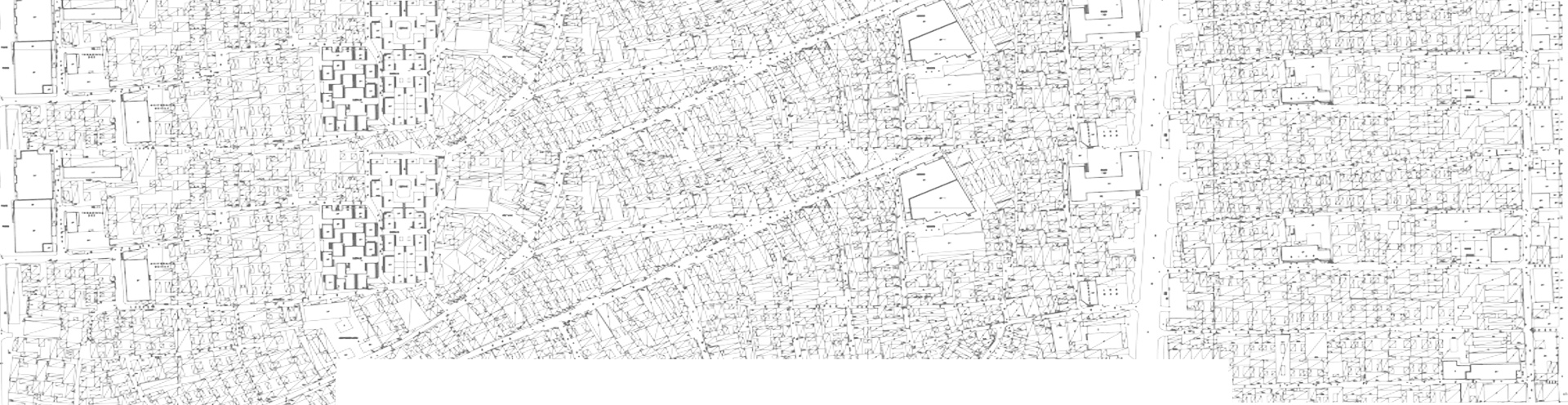
The constructing of the Chang’an City axial graph required that each Fang (Square) be drawn as a single building. As the basic unit of Chang’an City’s urban organisation and management, the Fang was relatively closed, with only two or four exits, and there are many lanes inside the Fang. Still, only a few were connected to the street outside the Fang. This way of drawing allowed a more intuitive view of the global integration of the entire outer city.
The global integration of Chang’an City in Figure 3shows that the highest integration value of Chang’an City was the two east-west streets adjacent to the East-West Markets. Chunmingmen Avenue, between Chunmingmen and Jinguangmen, was an essential life- line for the East-West Avenue through the city. The Imperial City and Xingqing Palace was representing political significance on the north side. The East-West Markets were holding the economic lifeline on the south side, and Chunmingmen Gate was leading eastward through the Hangu Pass to the East Capital, through which grain and other commodities from the economically developed areas in the Yellow River Valley and Yangtze River Valley were transferred west, from Jinguangmen up to Sichuan, Yunnan, Gansu, Long and the Western countries. Envoys, merchants and commodities from countries west of the Guanlong Region and Western Asia also came to Chang’an via this road [60]. Therefore, Chunmingmen Street is of traffic significance both from the political and economic perspec- tives. The second-highest level of integration across the city was on the south side of the East-West Markets. This high level of integration was due to being on the south side of the street immediately adjacent to the eastern and western markets, which also served as a diversion for Chunmingmen Street.
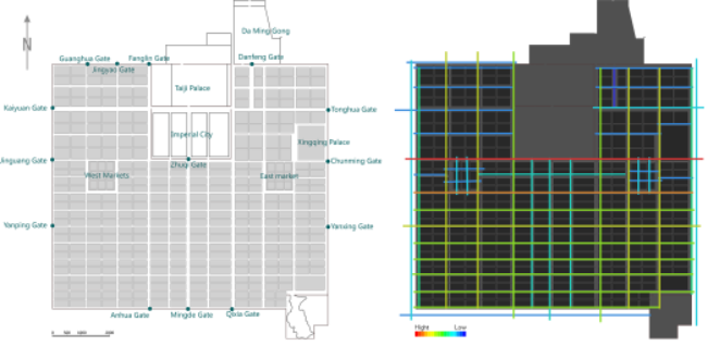
Figure 3. Global integration of the axes in Chang’an of the Tang Dynasty.
According to the global integration value of the Dongjing City in Figure 4, there were four significant red axes, including the New Fengqumen Street to Mahang Street, the street from Liang Gate to Old Cao Gate, Bianhe Avenue and the South-north Street from Xingguosi Bridge to the Chongming Gate. These were the main roads with good accessibility to link the central and peripheral areas. These streets were densely populated with commercial shops, close to the political centre, which constitutes the core space of Dongjing. The degree of integration in the periphery of the capital city was low, which may be because the outer city was planned with more military barracks and granaries located close to the outer city gates or water gates. This resulted in a less dense distribution of the road network, with poor accessibility and reduced population concentration compared to the commercial areas of the inner city.

Figure 4. Global integration value of the axes in Dongjing of the Song Dynasty.
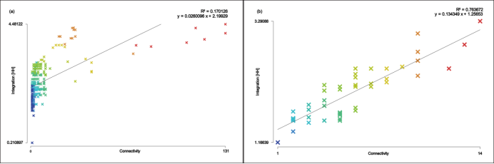
The global integration degree calculation was affected by the incomplete archaeo- logical and documentary data on both cities. Therefore, the local integration degree was applied for supplementary analysis. Local integration (radius = 3) reflects pedestrian movement. Before the analysis, it was necessary to verify the urban space’s local and global coordination through the synergy ratio. Synergy is the correlation value between the global integration value (radius = n) and the local integration value (radius = 3). It describes whether the local and global accessibility of the axes are consistent. Axial systems with
high synergy are more likely to reflect the whole through to the local. The closer R² of synergy is to 1, the more the tendency towards a single core. The closer it is to 0, the more the tendency of multiple cores, with low integrity. The ratios for the Chang’an City and Dongjing cities were 0.799 and 0.934 respectively. The results indicated that both capitals had a high synergy, that the local and global were coordinated, and that capitals’ cores tended to be unified single-core spaces (Figure 5a,b).
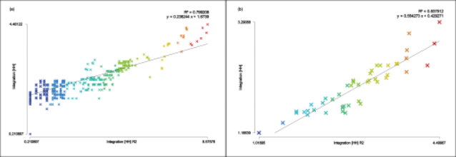
Figure 5. (a) Synergy of Chang’an of the Tang Dynasty and (b) synergy of Dongjing of the Northern Song Dynasty.
However, when calculating the local integration value of Chang’an, the street axes mapping previously carried out for global integration did not apply to the calculation of the local integration. This made it important to consider the street conditions and residential layout form within the Fang. There were 109 blocks as the basic urban community unit of Chang’an. There were two kinds of primary streets in the Fang, straight-lined streets and cruciform (cross) streets, with two or four exits, and the more subdivided alleys were called Qu. The traditional courtyard form was inherited from the Chang’an city, where the porch-yard style was still prevalent and the courtyard style had travelled, as seen in the Dunhuang murals and the typical courtyard in Beijing, as well as in the aerial view of the ancient city of Pingyao, which shows the arrangement of the houses (Figure 6). The house doors of the dwellings were distributed along the streets of the Fang and were neatly arranged. Therefore, the assumptions of the skeletal pattern of the streets within the block in Hui Sun’s article [61] (Figure 7) were used in the space syntax analysis for Chang’an.
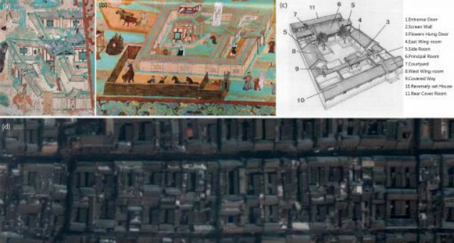
Figure 6. (a) Frescoes from Kiln 9 at Dunhuang; (b) frescoes from Kiln 85 at Dunhuang; (c) A typical three-story courtyard in Beijing [62]; (d) An overhead view of the ancient city of Pingyao.
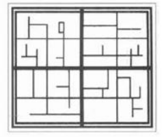
Figure 7. Assumed diagram of the internal street skeleton of the lanes in Chang’an of the Tang Dynasty from Hui and Jiang: Analysis on the Internal Structure of Fangli Units of Chang’an in Tang Dynasty, City Planning Review, 2003 (10), pp. 66–71.
As shown in Figure 8, the streets with higher integration value appeared on the Fang’s straight-lined and cruciform cross streets. The reason may be that, according to the policy, Fangs did not have direct access or open directly to the street. The streets outside the Fang only had the function of passing through, which reduced the possibility of people staying and gathering. Thus, the relative concentration of people where the local integration is highest was in the intersections or alleyways inside the Fang, which were connected to the street bordering the Fang and the subdivision of the Qu inside the Fan.
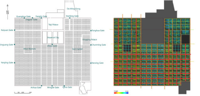
Figure 8. The local integration value of Chang’an of the Tang Dynasty.
The local integration value of Dongjing City almost coincided with the street with the highest global integration value (Figure 9). The street from Liang Gate to Old Cao Gate and the street from Xingguo Temple to Chongming Gate had the highest local integration values. The street from Liang Gate to Old Cao Gate, passing through the Xuande Men Square of the Imperial City, represented the royal family’s power and dignity. There was the Imperial Corridor on the south side. To the east, it went to Panlou Street via Zuoye Gate, where there was Panlou, a well-known restaurant. To the south, there were the Eagle Store, pearls, silk cape and incense shops, Jieshen Alley, a financial and monetary trading centre, and Sangjiawazi, the largest entertainment centre in the south. Further east were various kinds of restaurants, tea shops and hotels on Old Caomen Street. To the west was Yonglu Street via Youye Gate, where there were many inns, pharmacies, and hotels. The street from Xingguo Temple to Chongming Gate had Xingguo Temple, one of the capital’s religious centres. Many references about the Northern Song dynasty’s emperors were praying for rain or burning incense at Xingguo Temple, with many official offices and palaces nearby, hence the prevalence of people gathering at these intersections.

Figure 9. The local integration value of Dongjing of the Northern Song Dynasty.
Intelligibility is measures of axial map characterisation of global features, which to- gether reflect the city’s recognisability and can be used in a comparison between Chang’an city and Dongjing city. High intelligibility indicates that the spatial system’s local structure helps to build up a picture of the whole spatial system. However, many connected spaces cannot be well integrated into the overall system for cities that lack intelligibility. Therefore, relying on these visible connections will mislead the perception of this space’s position in the overall system [63]. In space syntax, intelligibility is represented by the regression coef- ficient R². R² values between 0 and 0.4 indicate that the coefficients are poorly intelligible. Between 0.4 and 0.7 indicate that the coefficients are intelligible, and between 0.7 and 1 indicate that the coefficients are extremely intelligible.
The intelligibility index of Chang’an is 0.170 (Figure 10a). The city with low intelligi- bility indicates that the local space is not closely integrated with the whole structure. The accuracy of predicting the whole through local space is low, and the local space in the Fang of Chang’an City was disconnected from the overall urban system. This result is consistent with the calculation of Chang’an City’s local integration, where the lanes inside the Fang were blue, and the streets outside the Fang were red. The contrast in local integration reflected the disconnect between the lanes in the city and the city streets. The reason for this is twofold, in terms of the structure of the Fang, which was the main residential unit in Chang’an City, each Fang was rectangular with two or four gates through which the residents of the Fang must enter. The Fang was built with walls, and residents were not allowed to open the doors directly to the street, except for the mansions of senior officials, and the residents of the Fang of special circumstances that were allowed to face the street (Figure11). A head was designated for each Fang in charge of the Fang’s affairs. This regulation created a relatively closed space in terms of urban management, reducing the number of entrances, and controlling the residents’ access, making it easier to manage [64]. Therefore, even though there was a rich street texture inside the Fang, there were only two or four roads that were identical to those outside the Fang, making it inconvenient for residents to enter and exit. From the perspective of urban spatial patterns, the spatial pattern of this capital was neater and tidier. It ensured the uniqueness of the Fang and market Gate entrance, but it also resulted in the Fang’s local centre not being well integrated into the overall spatial structure.

Figure 10. (a) Intelligibility of Chang’an of the Tang Dynasty and (b) intelligibility of Dongjing of the Northern Song Dynasty.
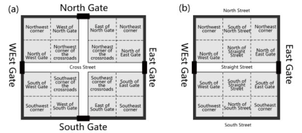
Figure 11. Two types of internal location map of the Fang in Chang’an [65]. (a) Nearly square-shaped Fangs, with doors on all sides. (b) Rectangular Fangs with only two side doors.
The intelligibility index of Dongjing City is 0.763 (Figure 10b). From economics and sociology, the higher the intelligibility, the better its local centrality can be integrated into the global spatial structure. Thus, it generates the multiplier effect of economic and social activities, making the spatial system more diverse and complex. The capital has a street market system formed after the collapse of the block market system. Although Dongjing City is the Northern Song Dynasty’s capital and has a strong political function, its urban pattern had a certain spontaneity. Based on inheriting the original road pattern, the street has been modified, and its development follows residents’ needs in the urban space. Streets and alleys are open and flexible, allowing for the rapid growth of commerce in the city and forming various markets scattered throughout the city.
7. Conclusions
The space syntax method enabled a quantitative representation of the spatial composi- tion and usage of the explored ancient cities. It facilitated the description and analysis of the relationship between physical space and social elements and provided tools to measure the city’s network of street spaces. Although the space syntax has been developed based on the study of modern urban planning, the use of a common methodology in the study of ancient and modern cities may lead to a common language in the study of cities. This, in turn, will result in new insights into the urban space, and a holistic study of ancient urban spaces of the past, that cannot be achieved by archaeology and literature review alone.
The method was used to study and compare based on the close relationship between urban network structure and human movement in Chang’an and Dongjing, making it feasible to transform findings into verifiable theories. It also made it possible to identify spatial configurations that cannot be seen in street plans based on qualitative analysis alone.
Some limitations in the analysis of space syntax were found, such as the inability to connect the calculation results with reality and the bias of the results due to the lack of urban information. Nevertheless, as a new quantitative spatial analysis method, space syntax provides a new perspective for analysing the spatial structure of ancient cities.
翻译
结构特征的比较分析
在本节中,轴线用于计算整体整合度(R=n)、局部整合度(R=3)、协同度和可理解度。然后利用分析结果解释城市总体空间结构。轴向视图中从红色到蓝色的轴线代表了最强到最弱的全球一体化。全球一体化的前10%中的轴线称为一体化核心,紧凑核心的形式反映了城市的基本形式。城市紧凑型核心区是整个城市人流聚集的中心。由于其在可达性方面的主导地位,紧凑型核心区比其他地区具有更强的社会和经济功能,因此成为城市社会活动的中心。
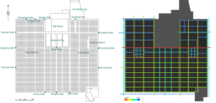
图 唐代长安轴线的全球整合
长安城的全球整合显示,长安城的最高整合价值是相邻东西市场的两条东西街道。春明门大道位于春明门和金光门之间,是贯穿全城东西大道的重要生命线。北面的皇城和兴庆宫代表着政治意义。东西市场是南边的经济命脉,春明门从汉沽关口向东通向东都,黄河流域和长江流域经济发达地区的粮食和其他商品从金光门向西转移到四川,云南、甘肃、龙和西方国家。来自关龙地区西部和西亚国家的使节、商人和商品也通过这条路来到长安[60]。因此,从政治和经济的角度来看,春明门大街都具有重要的交通意义。整个城市的第二高整合水平位于东西市场的南侧。这种高度的整合是因为位于紧靠东西市场的街道南侧,这也是春明门街道的改道。
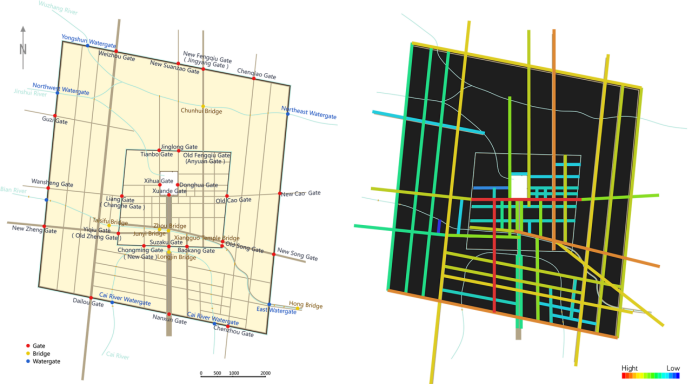
图 宋代东京轴线的全球整合价值
图中东京市的全球整合值,有四条重要的红色轴线,包括新的凤曲门街到马行街,从梁门到旧曹门的街道,边河大道和从兴国寺桥到崇明门的南北街。这些是连接中央和周边地区的交通便利的主要道路。这些街道上有密集的商业商店,靠近政治中心,构成了东京的核心空间。首都外围的一体化程度较低,这可能是因为外城计划在外城大门或水门附近修建更多的军营和粮仓。这导致道路网分布密度降低,与市中心商业区相比,可达性差,人口集中度降低。
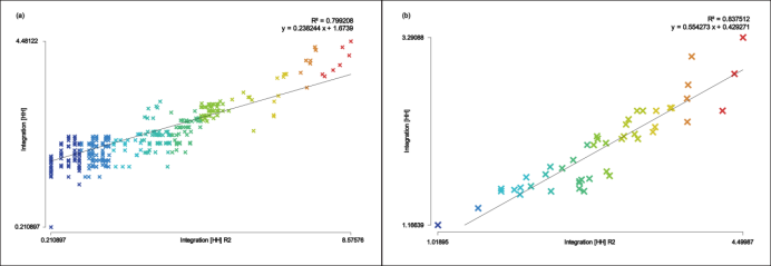
图 唐代长安协同与北宋东京协同
全球一体化程度的计算受到两座城市不完整的考古和文献数据的影响。因此,采用局部整合度进行补充分析。局部整合(半径=3)反映了行人运动。在分析之前,有必要通过协同比率来验证城市空间的局部和全局协调性。Synergy是全局积分值(radius=n)和局部积分值(radius=3)之间的相关值。它描述轴的本地和全局可访问性是否一致。具有高度协同作用的轴向系统更可能将整体反映到局部。synergy的R²越接近1,就越倾向于单一核心。它越接近于0,多核的趋势越大,完整性越低。长安市和东京市的比率分别为0.799和0.934。结果表明,这两个首都具有高度的协同效应,本地和全球是协调的,首都的核心往往是统一的单核心空间。
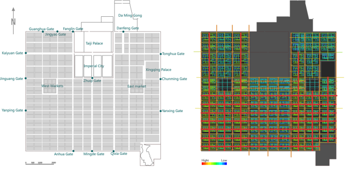
图 唐代长安的地方整合价值
如图所示,具有较高整合值的街道出现在方的直线和十字形交叉街道上。原因可能是,根据政策,方家没有直接进入或直接向街道开放。房外的街道只有通行的功能,减少了人们停留和聚集的可能性。因此,当地融合程度最高的人群相对集中在房内的交叉口或小巷,这些交叉口或小巷与房周边的街道和扇内的曲子区相连。
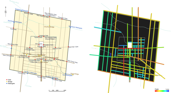
图 北宋东京的地方整合价值
东京市的本地整合值几乎与全球整合值最高的街道一致。从梁门到老曹门的街道和从兴国寺到崇明门的街道具有最高的地方整合价值。从梁门到老曹门的街道,穿过皇城的宣德门广场,代表着皇室的权力和尊严。南面有一条帝国走廊。往东,经左冶门进入板楼街,那里有一家著名的餐馆——板楼。在南部,有鹰店、珍珠店、丝绸斗篷店和香炉店、金融和货币交易中心杰申巷,以及南部最大的娱乐中心桑家洼子。再往东,曹门老街上有各种各样的餐馆、茶馆和旅馆。往西是永陆街,途经友谊门,那里有许多客栈、药店和旅馆。从兴国寺到崇明门的街道上有兴国寺,这是首都的宗教中心之一。许多关于北宋皇帝的参考资料都是在兴国寺祈雨或烧香,附近有许多官邸和宫殿,因此人们聚集在这些十字路口。
![]()
图 唐代长安的可懂度和北宋东经的可懂度
可理解性是全球特征的轴向地图特征的度量,它们共同反映了城市的可识别性,可用于长安市和东京市之间的比较。高清晰度表示空间系统的局部结构有助于构建整个空间系统的图像。然而,对于缺乏可理解性的城市来说,许多相互连接的空间无法很好地融入到整个系统中。因此,依赖这些可见的连接将误导人们对该空间在整个系统中位置的感知。在空间语法中,可懂度由回归系数R²表示。介于0和0.4之间的R²值表明系数的可理解性较差。介于0.4和0.7之间表示系数可理解,介于0.7和1之间表示系数非常可理解。
东京市的可懂度指数为0.763。从经济学和社会学角度来看,可理解性越高,其局部中心性就越能融入全球空间结构。因此,它产生了经济和社会活动的乘数效应,使空间系统更加多样化和复杂。在街区市场体系崩溃后,首都形成了街道市场体系。东靖城虽然是北宋的都城,具有很强的政治功能,但其城市格局具有一定的自发性。在继承原有道路格局的基础上,对街道进行了改造,其发展在城市空间上顺应了居民的需求。街道和小巷是开放和灵活的,允许商业在城市的快速增长,并形成分散在城市各地的各种市场。
结论
空间句法方法能够定量地表示所探索的古代城市的空间构成和使用情况。它有助于描述和分析物理空间和社会元素之间的关系,并提供了测量城市街道空间网络的工具。尽管空间句法是在现代城市规划研究的基础上发展起来的,但在研究古代和现代城市时使用一种通用的方法可能会导致在研究城市时使用一种通用的语言。反过来,这将导致对城市空间的新见解,以及对过去古代城市空间的整体研究,而这是仅靠考古学和文献综述无法实现的。
基于长安和东京的城市网络结构与人类活动之间的密切关系,采用该方法进行研究和比较,使研究结果转化为可验证的理论成为可能。这也使得仅基于定性分析就可以确定街道平面图中看不到的空间配置。
在空间句法分析中发现了一些局限性,如无法将计算结果与现实联系起来,以及由于缺乏城市信息而导致的结果偏差。然而,空间句法作为一种新的定量空间分析方法,为分析古代城市的空间结构提供了新的视角。
 收藏
收藏  支持
支持  反对
反对  回复
回复 呼我
呼我