


 发表于 2021-12-01 20:22
Exploring the Distribution of Gardens in Suzhou City in the Qianlong Period through a Space Syntax Approach
通过空间句法的方法探究乾隆时期苏州市园林的分布情况
作者: Yun Jiayan; Yu Wenbo; Wang Hao
摘要:
本研究通过空间句法与历史文本分析相结合的创新方法,探讨了乾隆时期(公元1736—1796年)苏州园林的空间分布。通过空间句法的方法,一个街道轴线模型分析认为,一个街道的整合和繁荣程度越大,其周围的园林分布越密集。一个运河轴线模型分析表明,在运河周围修建的花园较多,这些花园的集成度较低,交通较少。利用历史文献和图像验证了轴模型分析结果的准确性和可靠性。观察到以下几点:( 1 )园林密布于苏州市南北两端繁华商业区。一个园林的区位越繁荣,对其知名度的影响越大。( 2 )园区集中在商业活动活跃的居住区。( 3 )交通功能较差的运河沿线修建了大量园林。通过引水造园体现了城市地域特色与造园手法的互补关系。( 4 )园林促进了商业的发展,商业带动了园林的保存和延续。这一发现揭示了园林保存与商业开发的互补关系。
Abstract:
This study explored the spatial distribution of Suzhou gardens in the Qianlong period (AD1736–1796) through an innovative method combining spatial syntax and historical textual analysis.Through a spatial syntax approach, a street axis model analysis suggested that the greater the degreeof integration and prosperity of a street, the denser the distribution of gardens surrounding it. A canalaxis model analysis indicated that more gardens were built around canals that were less integratedand had less traffic. The accuracy and reliability of the axis model analysis results were validatedusing historical documents and images.
The following was observed: (1) Gardens were denselydistributed in the prosperous commercial areas at the northern and southern ends of Suzhou City.The more prosperous the location of a garden, the greater the influence on its popularity. (2) Gardens were concentrated in residential areas with booming businesses. (3) Large numbers of gardens were built along canals with poor traffic functions. Building gardens by diverting water into them reflected the complementary relationship between urban geographical characteristics and garden-building techniques. (4) Gardens promoted commercial development, and commerce drove the preservation and continuation of gardens. The findings revealed the complementary relationship between garden preservation and commercial development.
Keywords / 关键词
Suzhou city; Qianlong period; classical gardens; garden distribution/苏州城市;乾隆时期;古典园林;花园分布
1. 介绍
自明末(公元1368-1644年)以来,苏州作为当时的国家文化贸易中心[1 - 4],已成为一个商业繁荣、人口密集、地价高的[5]城市[6 - 8]。此时,园林文化已经渗透到生活的方方面面[9-11]。苏州市的大片土地被园林[12]所覆盖。明代有记载的园林有80多处,到清代(公元1644-1912年)有100多处,其中大多数是在乾隆年间建造的。乾隆年间是继晚明之后苏州园林大规模建设的又一时期。清代苏州园林的区位、规模、水源和艺术价值都深受城市发展的影响。园林与城市的内在联系是苏州城市景观和生活的重要组成部分。从明代到清代,苏州城市的空间结构也发生了一些小的变化。明代苏州城内街道约有500条,而乾隆年间则达到了612条。然而,通航运河的长度却从明朝晚期的92公里减少到1797年的57公里。城市空间结构的变化是否导致了明清苏州园林分布的变化?作为乾隆年间在苏州占用大量土地的项目,园林的空间分布特征与更大的城市空间结构有何关系?
1. Introduction
Since the late Ming Dynasty (AD 1368–1644), Suzhou City, the national cultural and trade centre at that time [ 1 – 4 ], had become a commercially prosperous and densely populated [ 5 ] city with high land prices [ 6 – 8 ]. By that time, garden culture had infiltrated all aspects of life [9–11]. Large areas of land in Suzhou City were covered by gardens [12].There were more than 80 recorded gardens in existence in the Ming Dynasty, and more than 100 by the time of the Qing Dynasty (AD 1644–1912) [ 13 ], a majority of which were built during the reign of Emperor Qianlong [ 14 ]. The reign of Emperor Qianlong was another period of large-scale construction of Suzhou gardens after the late Ming Dynasty. The locations, scale, water sources and artistic merits of Suzhou gardens were deeply affected by urban development in the Qing Dynasty [ 15 ]. The intrinsic association between gardens and the city was an important part of urban landscape and life in Suzhou City [16].From the Ming Dynasty to the Qing Dynasty, the spatial structure of Suzhou City also experienced some minor changes. There were about 500 streets in and around Suzhou City in the Ming Dynasty, whereas this number reached 612 during the reign of Emperor Qianlong. The mileage of navigable canals, however, had declined from 92 km in the late Ming Dynasty to 57 km in 1797 [ 17 ]. Did the change in urban spatial structure lead to the change in Suzhou garden distribution from the Ming Dynasty to the Qing Dynasty? As projects that took up large areas of land in Suzhou during the reign of Emperor Qianlong,what was the relationship between the spatial distribution characteristics of gardens and the larger urban spatial structure?
在过去的几年里,这个问题已经被一些研究者研究过了。田田的研究表明,从唐朝(公元618-907年)到清朝,苏州城内园林的分布受到苏州城内政治和商业中心布局变化的影响。唐宋园林主要分布在政治中心附近,明清园林主要分布在商业区[18]。Jen-shu通过对明清两代苏州园林分布图的比较,认为明代苏州园林多位于城市内的商业区。清代商业区域的变化导致了两代园林空间分布的差异。例如,在明代,封门地区的商业并不多,但到了清代,它发展成为一个重要的商业区域,成为一个集中的园林区[19]。Jing发现,在清代,新的苏州园林集中在城市的南北两端的边缘,而城镇中心的园林大多是在前(宋、明)时期建造的旧园林的基础上。她还认为,清代苏州园林布局的变化主要是城市功能变化的结果。苏州城市的政治中心从城市中心区域转移在明朝清朝的西部城市,和商业中心区域进一步扩大从苏州城市的西北部明代清代西北Changmen区域,这促进了花园向[20]区域的扩张。杨勇将明清时期苏州园林的大规模建设归因于城市商业的快速发展。
这些研究大多从宏观的角度对苏州园林分布进行比较,或将决定园林分布的主要因素归结为经济发展。然而,从微观角度研究苏州园林在一个历史时期的分布却很少。本文以《苏州城市图》中的街道、运河、园林地块为基础,运用空间句法分析了乾隆年间苏州园林的空间分布。首先,我们翻译了《苏州市地图》,并用科学的比例尺绘制了地图。我们运用空间句法分析了苏州城内具有重要交通功能的街道和运河的轴线模型,从而识别出当时苏州城市的总体空间结构。其次,基于街道和运河轴线模型计算结果,结合苏州园林区位,分析园林布局与城市空间结构的内在联系。最后,利用历史文献和图像验证了园林分布与城市空间结构之间的联系,在此基础上总结了苏州园林的分布特征。
不同于传统的城市园林史学研究中使用的历史文献和图像分析方法,本研究将城市历史研究中的空间句法结合起来,探讨苏州园林的分布。通过科学的空间句法方法与历史文献阐释相结合的研究方法,考察清代园林主要分布在商业区的原因。以往的研究并没有彻底挖掘园林与商业发展之间的关系。详细分析花园的乾隆时期的分布特征将有助于建立一个深入了解苏州园林的发展从明朝到清朝末期和识别花园的地理相关性的变化分布在过渡从明朝到清朝王朝。这一研究不仅为了解晚清苏州园林的分布提供了线索,也揭示了苏州园林在历史上是如何保存的。
Over the past few years, this issue has been studied by several researchers. A study by Tiantian showed that the distribution of the gardens inside Suzhou City from the Tang Dynasty (AD 618–907) to the Qing Dynasty was subject to the influence of changes in the layout of political and commercial centres in Suzhou City. Tang and Song gardens are distributed primarily near the political centre, and Ming and Qing gardens are distributed mainly in commercial areas [ 18 ]. By comparing the Suzhou garden distribution maps of the Ming Dynasty and the Qing Dynasty, Jen-shu argued that the gardens were mostly located in the business districts inside the city in the Ming Dynasty. The change in commercial areas in the Qing Dynasty caused the difference in the spatial distribution of gardens between the two dynasties. For example, the Feng Gate area did not have many businesses in the Ming Dynasty, but it developed as an important area for business in the Qing Dynasty, becoming a concentrated garden area [ 19 ]. Jing found that new Suzhou gardens were concentrated at the edges of the northern and southern ends of the city in the Qing Dynasty, whereas the gardens in the town centre were mostly based on the old ones built in the former (Song and Ming) dynasties. She also argued that the change in Suzhou garden distribution in the Qing Dynasty was primarily the result of the change in urban functions. The political centre of Suzhou City shifted from the city centre area in the Ming Dynasty to the western part of the city in the Qing Dynasty, and the commercial centre area further expanded from the northwest part of Suzhou City in the Ming Dynasty to the northwest Changmen area in the Qing Dynasty, which promoted the gardens’ expansion into that area [ 20 ]. Yong attributed the large-scale construction of Suzhou gardens during the Qing and Ming Dynasties to the rapid development of urban commerce [6].
These studies mostly compare the distribution of Suzhou gardens between several dynasties from a macroscopic perspective or attribute the major factor determining garden distribution to economic development. Few studies, however, have focused on the distribution of Suzhou gardens in only one historical period from a microscopic perspective. This study analysed the spatial distribution of Suzhou gardens during the reign of Emperor Qianlong using space syntax based on the streets, canals and garden plots shown in the Map of Suzhou City. First, we translated the Map of Suzhou City and plotted the map with scientific scales. We used space syntax to analyse the axis models of the streets and canals inside Suzhou City that bore important traffic functions, thereby identifying the overarching spatial structure of Suzhou City in that period. Next, we analysed the intrinsic connection of garden distribution to urban spatial structures based on the street and canal axis model calculation results in combination with the locations of Suzhou gardens. Lastly, we validated the connection between garden distribution and urban spatial structure using historical documents and images, based on which we summarized the distribution characteristics of Suzhou gardens.
Unlike the historical document- and image-analysis methods used in traditional historical research on cities and gardens, in this study, we integrated space syntax in urban history research to explore the distribution of Suzhou gardens. Through a research method that combines scientific spatial syntax methods with historical literature interpretation,we examined why Qing Dynasty gardens were distributed mainly in commercial districts.Previous studies have not thoroughly excavated the relationship between gardens and commercial development. A detailed analysis of the garden distribution characteristics of the Qianlong period will help establish an in-depth understanding of how Suzhou gardens evolved from the late Ming Dynasty to the Qing Dynasty and identify the geographic correlations of the changes in garden distribution during the transition from the Ming Dynasty to the Qing Dynasty. This research not only provides insights into the distribution of Suzhou gardens in the late Qing Dynasty but also reveals how Suzhou gardens were preserved throughout history.
2. 方法
2.1. 《苏州城市地图》的翻译
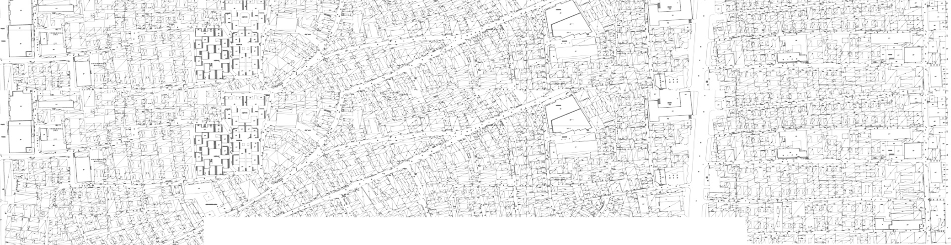
《苏州市图》绘制于1745年,是一幅清代中期以来的苏州古城地图。它是继宋代《平江城图》(公元960-1279年)和明代《苏州水源地图》之后保存最完整的地图。整个地图比例良好,定位准确,标签详细。《[21]图》中有612条街巷、128座寺庙、28座祠堂、25座政府大楼,以及100多处有文字注释的园林、农田,为将其翻译成科学比例尺的实用历史地图提供了有利条件。如图1所示,园林和农田分布在苏州市的南北两端;工商业中心位于西北地区常门附近;西南地区的政治中心位于徐门附近;丝绸织造区位于东北靠近楼门的区域,商业区位于东南靠近凤门[22]的区域。
2. Methods
2.1. Translation of the Map of Suzhou City
Drawn in 1745, the Map of Suzhou City is an ancient map of Suzhou City from the middle of the Qing Dynasty. It is the most complete map that has been preserved after the Map of Pingjiang City of the Song Dynasty (AD 960–1279) and the Water Sources in Suzhou Prefecture of the Ming Dynasty. The whole map is well scaled with accurate orientation and detailed labels. There are 612 streets and alleys, 128 temples, 28 ancestral halls and 25 government buildings, as well as more than 100 gardens and farmlands with text annotations in the map [ 21 ], which have provided a favourable condition for translating it into a practical historical map with scientific scales. As shown in Figure 1, gardens and farmlands were located at the southern and northern ends of Suzhou City; the industrial and commercial centre was situated in the northwest area near Chang Gate; the political centre in the southwest area was located near Xu Gate; the silk-weaving district was located in the northeast area near Lou Gate and the commercial district was located in the southeast area near Feng Gate [22].
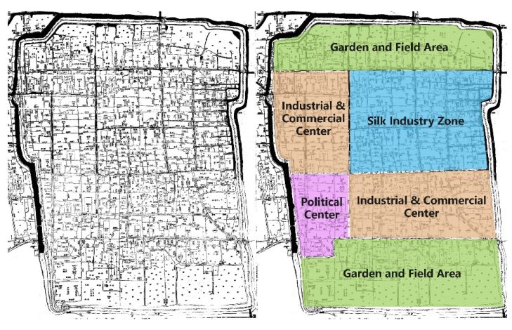
Figure 1. The Map of Suzhou City and its spatial distribution.《苏州城市地图与其空间组成》
 收藏
收藏  支持
支持  反对
反对  回复
回复 呼我
呼我