


 发表于 2021-12-21 16:59
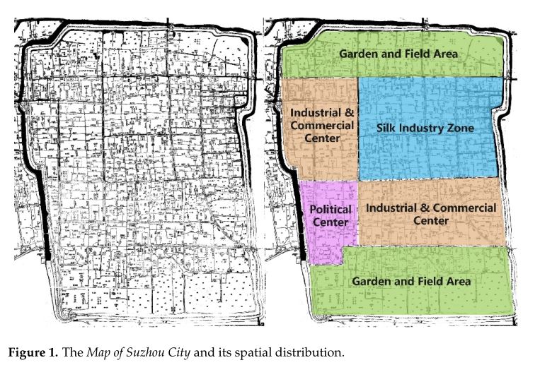
宜农在《中国城市的时空》中花了很大一部分篇幅来证明,尽管古代苏州的地图比例不科学,绘制也不正确,但其城墙和水系的空间拓扑结构是相当精确的。因此,基于不正确比例的古代地图,使用空间句法构建轴模型仍然是可行的。但是在我们的研究中,为了得到更准确的研究结果,我们将苏州市地图用科学的尺度进行了翻译。
利用地理信息系统(GIS),从苏州市地图中检索街道、运河和园林用地的数据。然后对苏州市的空间布局进行叠加分析。最后,将历史信息定位于苏州市现代城市空间,完成《苏州市地图》的翻译和绘制(图2)。 这些操作使用ArcGIS10.2软件完成。如上图所示,乾隆年间苏州城的街道呈棋盘状分布,向四面八方延伸;运河大多沿街而行。在苏州市南北两端的城墙附近有大片的园林地块和田地。市中心散布着一些较小的花园和田地。
Yinong dedicated a significant portion of The Chinese City in Space and Time to demonstrate that even though ancient maps of Suzhou were not scientifically scaled or correctly plotted, the spatial topology of city walls and the water system they included were fairly accurate [ 23 ]. For this reason, it was still feasible to build the axis models using space syntax based on incorrectly scaled ancient maps [24]. Nonetheless, for our study, the Map of Suzhou City was translated with scientific scales to obtain more accurate research results.
We used the geographical information system (GIS) to retrieve the data of streets,canals and garden plots from the Map of Suzhou City. We then superimposed data on the current spatial layout of Suzhou City. Lastly, the historical information was positioned in the modern urban space of Suzhou City to complete the translation and plotting of the Map of Suzhou City (Figure 2) [ 25 , 26 ]. These operations were completed using ArcGIS10.2 software. As shown, the streets of Suzhou City during the reign of Emperor Qianlong were distributed with a checkerboard pattern and extended in all directions; the canals mostly ran along streets. Large garden plots and fields were situated near the city walls at the southern and northern ends of Suzhou City. Some smaller gardens and fields were scattered throughout the town centre
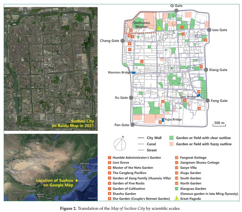
图2.科学比例尺的苏州市地图翻译。
2. 2.街道和运河的轴线建模和分析
2.2. Axis Modelling and Analysis of Streets and Canals
比尔●希利尔于1974年首次提出空间句法理论。他在《空间是机器》一书中对其核心概念“空间组构”的定义如下:“如果两个空间之间的空间关系被定义为任何形式的联系,如邻接或互连,当他们被连接到一个任何形式的第三空间的时候,他们最初的关系会受这种变化的支配,这其中就有组构”。 组构意味着一组关系,其中任何一个关系都依赖于与其相关的所有其他关系。空间句法作为一种空间结构分析方法,为城市空间的分析提供了科学合理的方法。在使用空间句法理论的研究中,通过生成街道拓扑模型并放大各种行为模式来模拟城市。与传统空间分析对空间的感性解读不同,空间句法分析可以识别空间形式与空间之间的相关性。空间形态对人类活动具有反馈和影响作用,因此形式与功能之间存有内在的逻辑联系。
Bill Hillier first proposed space syntax theory in 1974. He defined its core concept,“spatial configuration,” in Space Is the Machine as follows: “if the spatial relationship between two spaces was defined as any form of connection between them, such as adjacency or interconnection, the initial relationship between them was subject to change when either of them was connected to a third space in any form, and there was configuration in it” [ 27 , 28 ]. Configuration means a set of relationships, any one of which depends on all other relationships related to it. As a spatial structure analysis method, space syntax provides a scientific and rational way to analyse urban space [ 29 ]. In studies that use space syntax theory, cities are simulated by generating the topological models of streets and amplifying various behavioural patterns [ 30 ]. Unlike the perceptual interpretation of space by traditional space analysis [ 31 ], the analysis of space syntax can identify the correlation between space form and space. As space form has feedback on and influences human activities, an inherent logical connection exists between form and function [32].
我们利用空间句法轴线建模方法,结合AutoCAD, 在翻译后的《苏州城市地图》上以城墙为边界,手工绘制了街道和运河轴线图。然后将轴映射导入DepthMap中进行计算,然后检查NodeCount值,以验证轴映射和模型的准确性。
We manually plotted the axis map of streets and canals on the translated Map of Suzhou City with city walls as the boundary using the space syntax axis modelling method and AutoCAD. The axis map was then imported into DepthMap for calculation, which was followed by checking the Node Count values to validate the axis map and model accuracy.
在确认轴线绘制的准确性后,我们计算了街道和运河轴线模型的整合度。整合度是指空间系统中某一要素与其他要素之间的集聚或分散程度。它衡量了空间作为目的地吸引到达交通的能力,反映了空间在整个空间系统中的中心性。与其他街道的交叉口越多,街道的一体化程度越高,运河也是如此。与其他运河相交的数量越多,整合程度越高。空间的整合度越高,人们就越容易聚集在一-起,也就是说空间的集成度越高,人们就越容易到达。原则的某个地方的整合度越高,它就越容易被到达,可以提供更多的文化、经济、政治功能,我们分析了空间属性的城市花园地区分布来确定苏州园林的空间分布在乾隆皇帝的统治。
After confirming the accuracy of axis plotting, we calculated the integration of street and canal axis models. The degree of integration refers to the degree of agglomeration or dispersion between a certain element and other elements in a spatial system. It measures the ability of space as a destination to attract arriving traffic and reflects the centrality of the space in the entire spatial system. The greater the number of intersections with other streets, the higher the degree of integration of the street, and the same is true for canals. The greater the number of intersec-tions with other canals, the higher the degree of integration.The more integrated a space is, the easier it is for people to gather, which means that a more integrated space is more accessible [ 33 ]. based on the principle that the more integrated an area is, the more accessible it is and the more cultural, economic and political functions it can provide [ 33 ], we analysed the spatial attributes of the areas where urban gardens were distributed to identify the spatial distribution of Suzhou gardens during the reign of Emperor Qianlong.
3.结果
3.1.街道轴线模型分析
街道轴线模型分析(图3)表明,位于苏州市南北两端靠近古城墙的西北街和石泉街的整合度最高。即西北街和石泉街是苏州市与其他街道相交最多的街道。人们可以从多个街道到达西北街和石泉街,进一步说明这两条街道的可达性最大,是城市中人们聚集的地方。北起西北街,东至楼门。据乾隆年间的苏州本地人程章华说,“苏州市东部是楼关,店铺如星星般密集,各地商人云集”,“苏州市东部是楼门”。这一描述不仅说明了楼门区域是城市的重点商业区域,也间接证实了分析结果,即西北街是一个高度可达的街道。石泉街东接丰门。乾隆年间,苏州书生顾公谢曾写道:“盘门、封门旧时为荒凉之地。在乾隆初年,人们甚至懒得去看那里出售的豪宅。然而,现在他们发现他们根本买不起。
此报价描述了当时丰门地区地价快速上涨,商业活动频繁,也证实了分析结果的可靠性,即石泉街的整合程度最高。根据分析结果,大面积的花园分布在西北街北侧的一个或两个街区附近,少量的小块状花园分布在南侧。相反,在石泉街南侧的一个或两个街区内设置了多个街区式的花园,北侧则设置了一些小的街区式花园。苏州的街道呈棋盘状分布,各街区的分布和面积相对平均。每个地块南北长度约为150 m。乾隆年间,苏州市西北街一带园林最为密集;石泉街周边的园林布局仅次于西北街周边。可见,这一时期的苏州园林主要集中在高度可达的商业区附近,这与詹舒、用田的结论一致:明清时期的苏州园林主要集中在经济繁荣的地区。此外,我们的分析还纠正了荆氏关于乾隆年间苏州园林分布在城北和城南边缘的主要原因的观点。她认为这是因为那里有大量的土地,但这两个地区都是城市的核心商业区,土地短缺,也不是偏远地区。
3. Results
3.1. Street Axis Model Analysis
The street axis model analysis (Figure 3) indicated that Xibei Street and Shiquan Street,located at the northern and southern ends of the city near the ancient city walls, had the highest integration degree in Suzhou City. That is, Xibei Street and Shiquan Street were the streets that had the greatest number of intersections with other streets throughout the entire Suzhou City. People could reach Xibei Street and Shiquan Street from multiple streets,which further demonstrated that these two roads had the greatest degree of accessibility for people and thus were the places where people gathered in the city. Xibei Street in the north extended eastward to Lou Gate. According to Cheng Zhanghua, a Suzhou local during the reign of Emperor Qianlong, “The eastern region of Suzhou City is Louguan[Lou Gate] where shops are densely scattered like stars and merchants from all over the country gather” [ 34 ]. This description not only shows that the Lou Gate region was a key commercial area in the city but also indirectly confirms the analysis result—that is, Xibei Street was a highly accessible street. Shiquan Street joined Feng Gate to the east. Gu Gongxie, a scholar from Suzhou during the reign of Emperor Qianlong, once wrote, “Pan Gate and Feng Gate used to be desolate areas. In the early period of Emperor Qianlong, people would not even bother to take a look at the luxurious houses on sale there. However,now they find that they cannot afford them at all” [ 35 ]. This quote describes the rapidly rising land prices and frequent commercial activities in the Feng Gate area at that time [ 19 ]and also confirms the reliability of the analysis result—that is, Shiquan Street had the highest degree of integration.
According to the analysis result, large areas of gardens were located along one or two blocks adjacent to the north side of Xibei Street, and a few small block-shaped gardens were located on the south side. By contrast, multiple block-like gardens were located along one or two blocks adjacent to the south side of Shiquan Street, and some smaller ones were located on the north side. The streets in Suzhou are distributed in a checkerboard pattern, and the distribution and area of each block are relatively average. The north–south length of each block is about 150 m. Gardens were the most densely distributed in the area around Xibei Street in Suzhou City during the reign of Emperor Qianlong; the garden distribution around Shiquan Street ranked second to that around Xibei Street. Thus, it was evident that the gardens were concentrated near highly accessible commercial areas in Suzhou City in that period, which was consis-tent with the conclusions that Jen-shu and Tiantian reached:Suzhou gardens were mostly located in economically prosperous areas during the Ming and Qing Dynasties [ 36 ]. Furthermore, our analysis also corrected Jing’s opinion on the major reason why Suzhou gardens were distributed in the fringe areas at the northern and southern ends of the city during the reign of Emperor Qianlong. She argued that it was because that was where there was plenty of land [ 20 ], but both areas were the core commercial districts in the city that had shortages of land and neither were outlying areas.
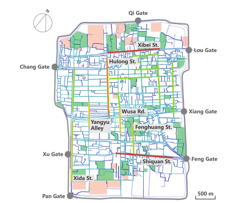
Figure 3. Street axis model analysis results. Streets marked in red are the most integrated streets, and those marked in dark blue are the least integrated streets. Streets with a higher degree of integration have more intersections with other streets, and streets with a lower degree of integration have fewer intersections with other streets.
图3.街道轴线模型分析结果。用红色标注的街道足整合程度最高的街道,深蓝色标注的街道是整合程度最低的街道。整合程度较高的街道与其他街道的交叉口较多,整合程度较低的街道与其他街道的交叉口较少。
湖龙街的整合程度仅次于西北街和石泉街。胡龙街连接苏州市西半部的吴县和东半部的常州市。这条街向南延仲到孔庙,向北延仲到大塔。作为一条主干道,它是连接许多棋盘状街区的主干道。但湖龙街沿线的园林较少,说明苏州市园林选址很少考虑交通要道。
After Xibei Street and Shiquan Street, Hulong Street had the third-highest degree of integration. Hulong Street connected Wu County, which was the western half of Suzhou City, and Changzhou County, which was the eastern half of the city. This street extended southward to the Confucius Temple and northward to the Great Pagoda. As a main road, it was the spine connecting a number of checkerboard-like blocks. However, few gardens were located along Hulong Street, suggesting that traffic arteries were seldom considered in garden site selection in Suzhou City.
西大街、杨雨巷、吴沙路、凤凰街在湖龙街的下方,在这些街道周围的一两个街区内设置少量的花园。西大街从南面的盘门开始,穿过熙熙攘攘的市场。大花园位于潘门附近。明清时期,杨屿巷、道前街等地方政府所在地被统称为道阳区。杨雨巷,沿街有各种各样的商店和商店,以前是政府官员的住宅区。沿着小巷也可以看到花园。沃沙路与凤凰街相邻,凤凰街南接石泉街。这两个街区的大部分建筑都是住宅,一 些花园也散布在它们周围。在此基础上,我们认为商业繁荣的居住区是苏州城市园林分布密集的另一种类型。
Xida Street, Yangyu Alley, Wusa Road and Fenghuang Street were below Hulong Street in terms of integration, and a small number of gardens were located in one or two blocks around these streets. Xida Street stretched from Pan Gate in the south and ran through bustling marketplaces [ 37 ]. Large gardens were located near Pan Gate. In the Ming and Qing Dynasties, Yangyu Alley and Daoqian Street, where local government offices were located, were collectively known as the Daoyang district. Yangyu Alley, along which was located all kinds of shops and stores, used to be the residential area of government officials [ 37 ]. Gardens also could be seen along the alley. Wusa Road was adjacent to Fenghuang Street, which joined Shiquan Street to the south. Most of the buildings along both of these blocks were residences and some gardens also were scattered along them. based on this analysis, we concluded that commercially prosperous residential areas were another type of area with densely distributed gardens in Suzhou City.、
如图3所示,在街道轴线模型分析中,浅绿色标记的街道为整合度平均的街区。它们是居民区,周围散布着少量的花园。其余的街道(浅蓝色和深蓝色标记)不仅整合程度较差,而且花园也较少分布在周围。比如西北街北侧和石泉街南侧沿区域延伸到城墙的街道,整合程度很低。虽然周围有大片的绿地,但苏州市地图显示这些绿地都是农田(图4)。在西北街和石泉街附近只有一两个街区有花园。苏州园林主要分布在城市的南北两端,在清代的鼎盛时期发展于商业和商住混居地区。很少有花园位于只有住宅功能的住宅区。由此可见,乾隆年间苏州园林的布局与城市的经济贸易区域紧密相连。花园更密集地分布在商业活动繁忙的地区。
As shown in Figure 3, the streets marked in light green in the street axis model analysis were blocks with an average degree of integration. They were residential areas around which a small number of gardens were scattered. The rest of the streets (marked in light blue and dark blue) not only had a poor degree of integration but also had fewer gardens distributed around them. For example, the streets along the area on the north side of Xibei Street and the south side of Shiquan Street that extended to the city wall had a very low degree of integration. Although large green areas surrounded them, the Map of Suzhou City has shown that these green areas were all farmland (Figure 4). only one or two blocks near Xibei Street and Shiquan Street had gardens. Suzhou gardens were distributed mostly at the southern and northern ends of the city and were developed in commercial and mixed residential–commercial areas during the peak of the Qing Dynasty. Few gardens were located in residential areas with only residential functions. Thus, we concluded that the distribution of Suzhou gardens was tightly connected to the economic and trade districts in the city during the reign of Emperor Qianlong. Gardens were more densely located in areas with busier commercial activities.
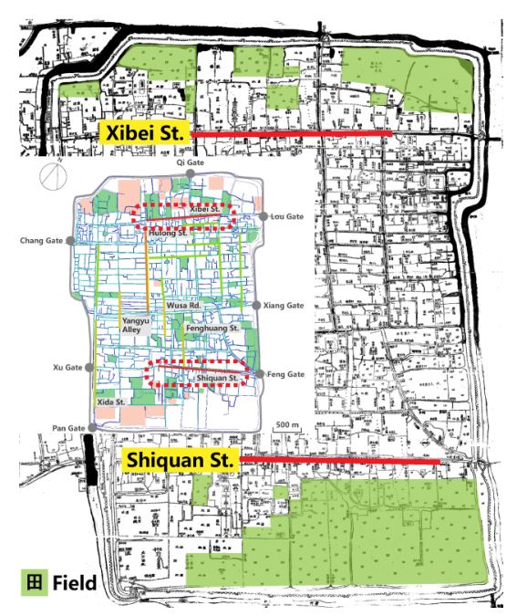
Figure 4. Fields on the north side of Xibei Street and the south side of Shiquan Street in the Map of Suzhou City.图4.苏州市地图西北街北侧、石泉街南侧田野
 收藏
收藏  支持
支持  反对
反对  回复
回复 呼我
呼我