


 发表于 2021-12-24 14:16
4 Case Study: Rod El Farag Park
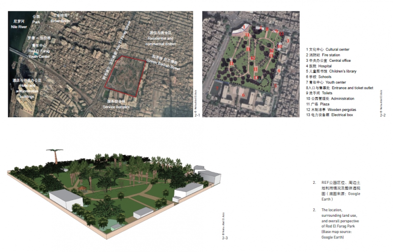
This research selected Rod El Farag Park in Cairo City, Egypt to assess the possibility of using space syntax theory in predicting crime patterns in urban parks. The park is located in a high-density informal district, and residents here are mostly lowincome citizens. The 38,200-square meter park was built up in 1997 after the regional vegetable market was relocated outside the city. The park is a part of a service complex, with large lawn areas and plazas with wooden pergolas (Fig. 2). Although the park is highly accessible and with a reasonable entry charge, it fails to attract most locals due to its bad reputation in poor safety and offending acts. Many criminal incidents were recorded here, driving out users from utilizing some zones in the park, which echoes Johannes Knutsson’s opinion that drug users and drug dealers find parks to be appealing locations to get high or to trade[22]. The park has one entry from the main street, and a gate (always closed) connects it to Rod El Farag Cultural Center.
4.1 Research Methods
In the first section of this research, two sets of interviews were conducted: one with the park’s management staff to collect data of illegal activities that were officially recorded, and the other with the park security team to acquire information about the non-documented incidents depending on their observations and memories. The collected crime data records were for the year 2019. Some violations were intervened by police forces; the others were solved by the local security personnel or the response of other visitors. The occurring places and types of both the recorded and non-documented crime events were then identified, and used to create a crime mapping to highlight the crime distributions. Crimes in the park were categorized into 4 types: crimes against oneself, crimes against others, dangerous crimes against others, and crimes against the park (e.g. vandalism). Criminal data were coded, 0 for none, and 1 for appearance, then mapped in ArcGIS 10.3. Besides, site observations were carried out in July (summer) and December (winter) at different hours of the day to record the activities and
users’ distribution. The second section was analyzing the parameters of the spatial configuration of the park using depthmapX, and the following tools were adopted:
1) Depth graph shows the number of topological nodes that must be crossed to go from one space to another. In a depth
graph, low values mean shallowness of space, while high values mean segregation[14].
2) Integration graph showing global integration values (degrees of syntactic accessibility) measures accessibility or mathematical closeness centrality, showing how likely a particular path segments is to be the destination for those using the network based on the position of the path segment in the network[23]. It can be used to predict users’ movements or their potential destinations.
3) Connectivity graph measures the number of spaces immediately connecting a space of origin.
4) Intelligibility shows how the environment is easily navigable, which means how easy an observer can be acquainted with his / her position in any location he / she may potentially occupy within the whole spatial system[14].
5) Visibility map presents the quality of natural surveillance by either park users or commuters passing by the park[2].
In these graphs, the analysis value ranges are represented by a gradient of colors ranging from dark blue to red: dark blue indicates lowest values and red indicates highest.
The impact of vegetation on visibility, connectivity, and accessibility is complex. Looking through branches of trees and shrubs enhances the visual connection and continuity, and offers
more open sightlines when compared with doing so in urban built environments, where buildings block users’ sightlines. Site visits helped with selecting objects that may block sightlines to be added to the visibility graph, such as buildings, pergolas, kiosks, and obstructing vegetation. Seats and other site furniture were excluded as they rarely block people’s sight. based on site visits, vegetation in the site was categorized into two groups. One group is medium and large trees with dense canopies and relatively short trunks (providing low visual permeability, i.e. high opacity), which were added to the visibility map. The other group included palm trees (very high trunks), trees with small crowns and high trunks (providing low opacity), short shrubs (less than 50 cm), and ground covers, which were excluded as they do not affect sightlines. Considering that most vegetation in the park is mature and the dynamic vegetation density throughout the year would impact the visibility and the use of space, scenarios of both the summer and the winter were
implemented to acquire the fluctuation in visual connectivity with the crime pattern. The summer scenario took both evergreen and deciduous trees into consideration, while the
winter one excluded deciduous trees as they do not represent visual obstacles (Table 1). Pictures of the park trees in the summer and the winter were collected to determine the opacity of their canopies and trunk heights (Fig. 3).
4.2 Limitations
Using space syntax in landscape studies arises many predicaments, such as defining clear boundaries of spaces since they are not well defined by walls or buildings as in urban context (Fig. 4). In their research, Zhai Yujia and Perver Baran[2] proposed that boundaries between spaces are defined by spatial functions and design intentions, and they raised the question that whether to consider activity areas and pathways equally in the system. Thus, this study regarded paths and plazas equally in defining the park’s spatial configuration, excluding lawn areas that are not intended for use though some people do use. In addition, the research had to acquire locations and occurrence time of those unrecorded crimes depending on the memory of the security team, which was therefore not accurate. depthmapX is a 2D software that cannot deal with data regarding tree opacity, height, spread, or growth rate. Moreover, terrains were not included in the model. Finally, space syntax in this research ignored the superficial appearance of the environment, including surface colors and textures, and discarded the effect of activities in attracting pedestrian flows.
4 案例研究:罗德-法拉格公园
本研究选取埃及开罗市的罗德-法拉格公园(以下简称REF公园)来探索运用空间句法理论预测城市公园中犯罪行为的可能性。该公园位于一处高密度非正式聚居区,周边居民大多是低收入者。公园面积为3.82h m2,于1997年建成,场地原为当地的一座蔬菜市场。RE F公园隶属于一个服务综合体,内有大片草坪和带有木制凉亭的广场(图2)。尽管公园交通便利,门票价格合理,但由于存在安全隐患及犯罪率较高而难以吸引当地居民前来,公园内多处区域现已无人使用,反而成了犯罪分子的聚集区—正如约翰尼斯·努特森所说,许多吸毒者和贩毒者都认为公园是吸毒或毒品交易的理想场所[22]。公园只有一个通往城市主干道的入口,而通往罗德-法拉格文化中心的大门则常年关闭。
4.1 研究方法
研究首先进行了两组采访:一组针对公园管理人员,目的是获取已记录在案的公园非法活动相关资料;另一组针对公园保安团队,通过他们的日常观察与记忆了解那些未被正式记录的公园犯罪情况。研究跨度为2019年全年,其中部分犯罪事件已由警方处理,另一些则由
当地保安人员处理解决或由公园游客制止。研究者根据这些信息判别已记录及未记录犯罪发生的地点与类型,并绘制了公园内犯罪事件的分布图。REF公园内发生的犯罪分为4种类型:自我危害行为、危害他人行为、严重危害他人行为,以及危害公园行为(如破坏公物)。研
究在ArcGIS 10.3软件中根据犯罪发生情况对公园各区域进行编码,0表示无犯罪,1表示有犯罪发生;并分别在2019年夏季(7月)和冬季(12月)一天中的不同时段对公园场地进行观察,以了解使用者活动及分布情况。第二部分是使用depthmapX软件分析公园的空间布局参数,涉及的工具主要包括:
1)深度分析图:用于表示从某一空间到达另一空间必须经过的拓
扑节点数量;数值越小代表空间深度越浅,数值越大代表空间分离度
越高[14]。
2)全局整合度(句法意义上空间的可达程度)分析图:用于表征
空间可达性或数学意义上的邻近中心度,即反映了空间网络中某一特
定路段为行人所踏足的可能性[23],可据此预测行人的移动趋势或网络中
潜在的目的地。
3)连接度分析图:用于衡量直接与原点空间相连的空间数。连接
度是指与给定线段直接相连的线段数量。
4)可理解度分析图:反映环境中寻路的难易程度,即观察者在整
个空间系统中从任一位置到达另一位置的容易程度[14]。
5)可见性分析图:用于表示公园向使用者或路过者所提供的自然
监视的质量[2]。
分析得出的具体空间布局数值范围均以从深蓝色到红色的色阶表示。蓝色表示低值,红色表示高值。植被对空间可见性、连接度和可达性的影响较为复杂。与充斥着大量建筑物、视线极易受阻的建成环境相比,透过乔木和灌木枝叶进行观察可以增强视觉连接度、连续性,并提供更开阔的视线。
经过实地考察,研究将建筑物、凉亭及售货亭作为可见性分析图中的阻碍因素,但不包括座椅等不会遮挡视线的户外家具。根据实地观察结果将公园内的植被分为两类,一类是树冠茂密但树干分叉较低的中型及大型乔木(视线通透性低,即树冠不透明度高),它们被视为可见性分析中的阻碍因素;另一类包括棕榈树(树干极高)、树冠较小且树干较高的其他乔木(树冠视觉通透性高),以及低矮灌木(高度低于50cm)和地被植物,本研究不将它们看作视线阻碍因素。由于公园中绝大部分为成熟植被,一年中公园的植被密度变化较大,这会影响空间的可见性和使用情况,于是研究分别计算了夏季与冬季公园空间的视觉连接度及相应的犯罪事件分布情况。夏季情景将常绿和落叶乔木都考虑在内,冬季情景则不考虑落叶乔木(表1)。笔者收集了这些树木在夏季和冬季的照片(图3),以确定每种树木树冠的不透明度和树干高度。
4.2 研究方法的局限性
运用空间句法对景观进行研究也存在许多困难,因为景观中的空间并不像建成环境中的空间那样,以墙体或建筑物作为明确的边界(图4)。翟宇佳和珀维尔·巴兰指出,空间的边界是由空间功能和设计意图决定的,进而提出了一个问题:在空间句法分析中是否应对道
路和活动区域运用同样的处理方式?[2]因此,本研究在定义公园空间布局时将小径和广场同等对待,但不包括原本未被设计为活动区域的草坪(尽管实际上已有人在这些草坪上活动)。其他难点包括:研究只能依靠保安团队的回忆来获知未记录在案的犯罪行为的发生地点和时
间,而这些数据的准确性无法保证;作为2D软件,depthmapX不支持输入乔木的树冠通透度、高度、覆盖率和生长速率等数据,也无法模拟地形特征,因此本研究的空间句法分析没有考虑颜色和纹理/材质等环境外观特征,以及活动对人群的吸引效果。
 收藏
收藏  支持
支持  反对
反对  回复
回复 呼我
呼我