


 发表于 2021-12-24 14:27
5 Results
5.1 The Crime Mapping of the Park
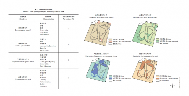
After analyzing the crime data (Table 2), results showed that crimes against oneself, like drug and alcohol abuse, were the most common crimes in the park. They can be tracked by the waste left behind (e.g. needles and bottles). In the second place came crimes against the park represented by littering, public urinating, graffiti, and vandalism including breaking tree branches, carving in trees, spraying seats and pergolas, and dismantling wooden benches and trash bins. Teenagers’ inappropriate behaviors, quarrels, and harassment followed in the third place. As for dangerous offenses against others, theft was in the lead, then armed fights, and few cases of kid’s kidnapping attempts. Crimes were mainly found at the park periphery and the west section, whereas the central area of the park was considered safe and free from criminal activities (Fig. 5).
5.2 Spatial Configurations Analysis of the Park
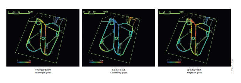
The result of the space depth analysis (Fig. 6-1) shows that the area around the toilet in the north and the southern section of the park had the highest depth values, indicating that these
two areas were the most spatially isolated, while the plaza in the north section and the two main paths in the center of the park had the least depth values. The rest of the park is intermediate in space depth. As for the connectivity analysis (Fig. 6-2), the two paths in the center of the park and the north plaza were the most connected areas; the entrance, the plaza in the center, and the southern section were the most disconnected areas. In regards to integration analysis shown in Figure 6-3, it was found that the most spatially integrated path is the one connecting the north
plaza with the southern section. In contrast, paths in eastern and southern parts of the park had the least integration with the other paths and spaces.
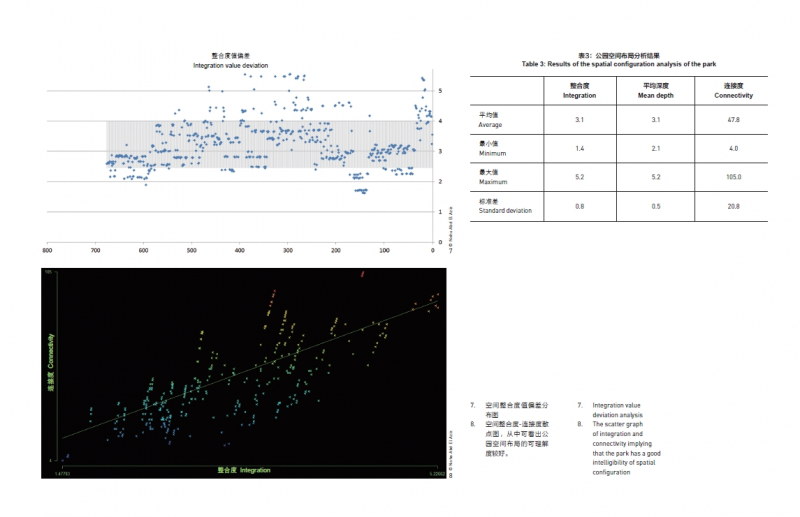
Figure 7 displays the integration value deviation, showing that half of the park integration values are close while the other half is either highly integrated or disconnected. Additionally, the intelligibility of the park was measured by investigating the relation between the connectivity of space and its integration (Fig. 8). In terms of the degree of intelligibility, the correlation coefficient between integration and connectivity was 0.70, indicating that spaces / paths with high integration are also highly connected and intelligible. However, integration and mean depth saw a negative correlation (correlation coefficient was -0.94), so did mean depth and connectivity (correlation coefficient was -0.69). The spatial configuration analyses are summarized in Table 3.
5.3 Visibility Graph Analysis
In the visibility analysis, paths and lawn areas were treated the same. It is important to note that the park cannot be seen from the surroundings due to trees, buildings, or metal sheets covering the park fence (Fig. 9).
A radial visibility distribution pattern was found in both the summer and the winter. The park center was the most visible zone, while the park periphery was the least visible section. Since there are few buildings and pergolas at the site, their impact on visibility was localized. The negative effect of the deciduous trees (black dots on the graph) can be noticed in the summer scenario (Fig. 10-1), as they shrunk highly visible areas. In the winter scenario, the eastern and western sections were more visible due to sightline penetrating the translucent tree canopies (Fig. 10-2).
5 研究结果
5.1 公园犯罪地图
对犯罪数据(表2)的分析结果表明,吸毒和酗酒等自我危害行为在REF公园中最为常见,可以通过留下的垃圾(针头及酒瓶等)对其进行追踪;其次是危害公园行为,包括乱抛垃圾、随地小便、涂鸦,以及破坏公物行为(包括爬树、折断树枝、在树上乱涂乱画、喷涂座
椅和凉亭,以及破坏木凳和垃圾桶)。其后是青少年的不雅行为、争吵及寻衅滋事行为。在公园发生的严重危害他人行为中,盗窃的比例最高,其次是持刀斗殴,绑架儿童事件也偶有发生。犯罪行为主要发生在公园外围和西侧,而公园中心区域较为安全,几乎没有犯罪发生(图5)。
5.2 公园空间布局分析
空间深度分析的结果(图6-1)表明,公园北部的洗手间周边和南部区域的空间深度值最大,即洗手间周边区域和南部区域在空间上是高度隔离的;北部广场和公园中部两条主要道路的空间深度值最小;公园的其余区域深度值为中等。连接度分析结果(图6-2)表明,公园中部的两条道路和东北部的广场连接度最高,公园入口、中央广场和南部连接度最差。整合度分析结果(图6-3)则表明,将北部广场和公园南部区域相连的道路空间整合度最高,东侧和南侧道路的整合度最差。图7显示了整合度值分布的偏差情况,其表明公园内约一半地点的空间整合度值适中且较为接近,而另一半地点的空间整合度值则呈显著的两极分化。此外,研究也分析了空间连接度与整合度之间的关系,即空间的可理解度(图8):整合度和连接度之间的相关系数为0.70,表明整合度高的空间或路径连接度也较高,而整合度与平均空间深度,以及平均空间深度与连接度之间则呈负相关(相关系数分别为-0.94和-0.69)。各项空间布局分析结果见表3。
5.3 可见性图分析
在可见性研究中对道路和草坪区域进行了无差别处理。值得注意的是,由于存在树木、建筑物及覆盖着金属薄板的栅栏等遮挡物,无法透过公园外围看到其内部(图9)。结果表明,整个公园的可见性在夏季和冬季均呈辐射状分布,即中心区域可见性最高,外围可见性最低。由于公园内建筑物和凉亭极少,因此对可见性的影响范围较小。落叶乔木(图中黑色圆点)对可见性的负面影响在夏季较为显著,致使高可见性区域明显缩小(图10-1);在冬季,树冠的通透度较高,因此公园东部和西部区域的可见性有所提升(图10-2)。
 收藏
收藏  支持
支持  反对
反对  回复
回复 呼我
呼我